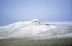
Photo by Rick GunnHigh on the spine of the Ruby Mountains overlooking Ruby Marsh, Nevada Appeal staff writer and Nevada 10-in-10 adventure team member Karl Horeis makes his way along the 42 mile trail.
Walking along a narrow strip of trail that follows the spine of one of the most rugged and remote mountain ranges in United States seemed difficult enough. Doing it all in one day seemed nearly impossible.
And this was all before we would abandon a total stranger's puke-green truck on the west side of the Ruby Mountains, before being attacked by cows and before being so exhausted during rest breaks that we didn't care if we ever awoke from our customary naps.
"J-Dogg watch out," yelled Rick Gunn, as he and K.M. Cannon started running toward me with scared, blank faces.
I stopped, then heard what sounded like several house-size boulders tumbling through a thick aspen grove above us. The peaceful hum of aspens in the cool morning breeze gave way to a destructive noise that was only getting louder.
The aspens were dense and beautiful, providing a stark, lush contrast to the brown desert valley floor to the west. But now they were making me angry.
The three of us couldn't see anything. We would never know when the boulders would smash our craniums, the same way a 20-foot wave crashes on three blind surfers. We were totally defenseless. I ran toward Rick and K.M. like I was greeting my mother at the airport after a two-year vacation.
When the noise had crept terrifyingly close, two cows suddenly crossed the trail. It seems as though Karl Horeis, who was ahead of us, spooked three cows near a stream. One cow went downhill and the other two bolted up the hillside, before nearly trampling us.
It was only 7:30 a.m.
"What the hell is going on here?" I asked. "Cows. What kind of trail is this?"
This was the Ruby Crest National Scenic Trail, a 42-mile gem, which stretches from Harrison Pass in the south to Lamoille Canyon in the north. We had borrowed the truck of Appeal reporter Teri Vance's father, a two-wheel drive beast that would give us a head start via a jeep road originating at Harrison Pass. This road actually is the RCT until it becomes too narrow, too rocky and too treacherous for vehicles. About 5 1/2 miles in, we had reached that point, but couldn't turn the truck around.
In the dark hours before sunrise, Karl drove incredibly well considering the truck shouldn't have been on this road. But no driver in the world could've turned the truck around where we tried. Karl was able to make one point of a three-point turnabout, but eventually got the truck stuck on the downhill side of the road. There was simply nowhere the truck could go, except into an aspen-filled canyon 1,00 feet below. So we left it.
This was at 6:30 a.m.
Already less than two hours into what would be a 17-hour day, Nevada's most spectacular row of peaks, which are known as the "crown jewel of the Great Basin," threw two solid curve balls at us.
I had been infatuated with the Rubies in the weeks leading up to the Nevada 10-in-10 Challenge. After completing challenge No. 5, the Bloody Shins Trail near Winnemucca, I no longer wanted to see the Rubies. My knees had aged 60 years on the drive from Humboldt County along Interstate 80 through towns like Battle Mountain, Carlin and Elko.
And the thought of hiking a trail in one day that most experienced hikers take at least four days to do didn't seem like it would be much fun. But we weren't doing these challenges for fun.
This particular challenge challenged the body, mind and soul. And it was extremely painful. There were so many disappointments on the trail that a box of Kleenex wouldn't have been able to soak up all of our sobbing.
At about 9:30 a.m., we had a reached an exposed notch over 9,000 feet. We were so excited because we thought that would be all the elevation we would gain for the day. Now all we had left was a level hike to Overland Lake, 9,500 feet high in the Nevada desert sky, which floats gracefully underneath sparkling granite cliffs.
From the notch, we looked at an obvious trail over 2,500 feet below, which was switchbacking up another steep ridge in the distance. We were convinced that couldn't be our trail. But this was Elko County, not exactly a hiking hotbed. How many hiking trails could there be? Sadly, we soon found out that trail was the RCT.
We descended down the 2,500 feet, then climbed over a 1,000 feet to another notch, only to descend 1,500 feet into another canyon, only to climb almost 3,500 feet over an 11,000-foot pass before descending to Overland Lake.
It was now 12:30 p.m.
We looked at the jagged peaks to the north and we knew beneath one of them was the end of Lamoille Canyon Road. On a normal backpacking trip, the trip to Overland Lake would've have been a healthy day's work, almost 15 rugged miles from Harrison Pass. From here, we foolishly convinced ourselves we had reached the spine of the Rubies and would simply stay high for the last 18 miles or so. Wrong again.
About 500 feet below Overland Lake, we saw a wooden sign nailed to a tree that read 'Favre Lake -- 24 miles.'
Favre Lake was six miles from our destination in Lamoille Canyon, where a 28-foot RV loaded with drinks, food and beds.
"You got to be kidding me," I said.
"Holy (expletive)," I heard somebody said. "We better get going."
In almost a trance, we scaled one 10,000-foot peak after another. At the top of each peak, we would rest, then regretfully descend the peak, then climb another. It took as almost three hours before finally reaching 10,998-foot Wines Peak, the highest point on the trail.
The landscape was moon like, with barren expanses of dirt giving way to steep cliffs staring at the Ruby Valley to the east and more gradually towards Spring Creek to the west. We could finally see where Liberty Pass, which was still several hours away. From this point, it was as if I stepped out of my despicable body and was driven by something unexplainable because I only remember reaching Liberty Pass and nothing in between. We regrouped at the pass, exchanged handshakes, then made the sharp two-mile descent to the RV, with only headlamps to lead the way.
Still high above the RV, we could see a light flickering below us. It was our driver, Don Quilici, and his wife, Elaine, acknowledging they could see our headlamps. I wanted to kill the both of them, teasing me with such pleasure. Not long after my sixth blister popped on a sharp rock, the light that once looked like a micro dot was now in our face and blinding. We had made it.
It was 10:30 p.m.
Less than nine hours later we would be hiking Wheeler Peak, challenge No. 7, more than 300 miles away.

Comments
Use the comment form below to begin a discussion about this content.
Sign in to comment