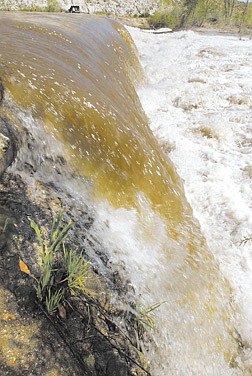
The Carson River roars over Mexican Dam Saturday morning.
Carson River is expected to reach its peak flow for the year this weekend as warm temperatures melted snow, drawing fresh water to feed the valley floor.
The spring flow will be a good test for environmental improvements put in place to prevent banks from washing away and eroding into the river stream.
At 3 p.m. Saturday the U.S. Geological Service's monitoring station near Mexican Dam recorded a flow of 2,260 cubic feet per second. Though the river was high, the flow was minimal compared to the 30,500 cubic feet per second that coursed through the same station during the New Year's Day Flood of 1997. The gauge recorded no flow on Sept. 5, 1992.
Although local, federal and state agencies and conservation groups continue to make progress in cleaning up the river, they still face the challenge of keeping pace with development in fast-growing Douglas and Lyon counties and balancing that with environmental concerns.
The river, which runs from Markleeville to the Carson Sink east of Fallon, was identified earlier this month by the U.S. Interior Department as highly likely to experience water conflicts by 2025. Officials say if the area continues to grow at the same rate as today, it is estimated the demand for the water it provides will be exceeded by 2050.
One challenge the area faces is the lack of water storage to carry over water from an abundant spring runoff to the end of summer, for instance, when demand is high and the water is low, said Ed James, general manager of the Carson Water Subconservancy District.
"If you look at Carson's watershed, you have demands for new growth, you have environmental demands and agricultural demands," James said. "So you have to balance all those demands with limited resources on the Carson River."
Much of what was identified as potential problems for the river by the U.S. Interior Department is being addressed, James said. Local groups are looking at finding areas where water can be stored either underground or in above-ground tanks.
"I think (the federal department) realizes we have no upstream storage, like a reservoir," James said. "We are really at the mercy of Mother Nature. We could have a flood one year and the next year a drought. There is no way to carry the water over."
A regional plan for the watershed is being developed by state and federal agencies, which will take a look at what the area might need in the next 25 years, James said.
The plan may look at a way to balance how much of the watershed should stay agriculture, which in turn provides open-space habitat for eagles and other wildlife, and what areas could sustain growth.
Many groups and local governments have made improvements to the banks of the river in the past few years, stabilizing areas that were prone to wash away with a storm or heavy spring runoff. Because the river has been altered for agriculture use and by property owners in some areas, the river flows faster than it would naturally.
Alterations to the river bottom and the clearing of trees and vegetation along the banks also have caused the water to heat up to a temperature that has killed off fisheries and wildlife habitat in sections of the river. What was once there to shade the water has been cleared, allowing the sun to penetrate to a flatter bottom in some areas, James said.
The river is currently in violation of the federal Clean Water Act in spring and summer when phosphorus levels and warm temperatures climb. Studies are being done to determine where the sources of phosphorus are located and whether the federal standards should apply to the environment, James said.
"It will help us better understand where to focus resources to fix problems," James said.
Kevin Piper, district manager of the Dayton Valley Conservation District, said his group is working on projects to aid stream bank stability, riparian, wildlife habitat and water quality.
The district recently restored 2,000 linear feet of riverbank in the Dayton area. The silty, sandy soils are stabilized by planting native vegetation, he said. The projects help local property owners keep their property along the river. "There's not much we can do during spring runoff," Piper said. "Hopefully the projects we've installed over the last years (will help). It's just a matter of seeing what spring runoff does and where are the real areas of concern."
River flows for Saturday, May 24, 2003
Carson City
Station is 3 miles upstream from Lloyd's Bridge, elevation 4,620 feet above sea level. Flow at 3 p.m. 2,260 cubic feet per sec. Maximum for the day 3,980 cfs.
Gardnerville
Station is 7 miles southeast of Gardnerville, elevation 4,987 feet above sea level. Flow at 5:30 p.m. was 1,520 cfs. Maximum for the day 4,150 cfs.
Fort Churchill
Station is 2 miles west of Fort Churchill, elevation 4,180 feet above sea level. Flow at 6:15 p.m. was 2,000 cfs. Maximum for the day was 3,650 cfs.
ON THE NET
To find out real-time river flow levels, visit www.usgs.gov

Comments
Use the comment form below to begin a discussion about this content.
Sign in to comment