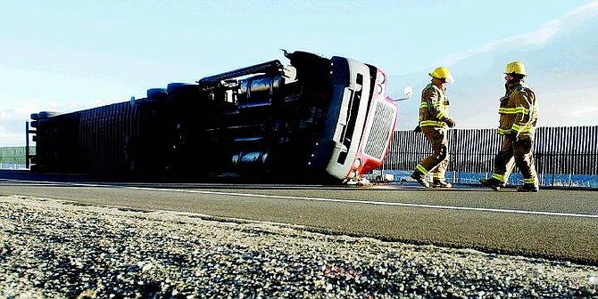
BRAD HORN/Nevada Appeal Carson City Firefighters clean up Old 395 just North of Eastlake Boulevard in Washoe Valley Friday morning.
Winds gusting up to 80 mph knocked out traffic lights, hurled signs and blew over three commercial trucks in the Carson City area Friday morning. No one was seriously injured.
The first truck was blown over near the off ramp from Highway 395 onto State Route 429 in southern Washoe Valley, Old Highway 395. A wind advisory message board put up by the Department of Transportation warned commercial truck and drivers against driving along Highway 395.
"At approximately 8 a.m. the first guy blew over just as he was leaving the highway," said Nevada Highway Patrol Trooper Rob Stepien.
"He completely blocked traffic on 429 for a full hour until we got it moved off to one side."
Winds slamming into the truck kept crews from getting it upright for several hours. Because tall vehicles were required to take the blocked route, trucks backed up along the highway on Lakeview Hill.
"At about 9:30 one of those drivers decided he didn't want to wait, so he drove down to 395," Stepien said. That truck blew over shortly after, blocking both northbound lanes. The driver, whose name was not released, received minor injuries but was not taken to a hospital. He was cited for disregarding the warning signs and fined $280.
Another truck blew over Friday morning on Highway 88 outside of Gardnerville, but no one was seriously injured in that accident either.
"It's been a long time since I can remember three trucks going over due to wind in one morning," Stepien said. "Luckily none of them were hauling any hazardous materials."
The truck which tipped over on Highway 395 after the driver ignored warning signs spilled some diesel fuel. The Department of Transportation cleaned it up.
The heavy winds Friday morning were caused by a "tight pressure gradient," according to Chris Jordan, meteorologist with the National Weather Service in Reno.
That means the ridge of high pressure and the trough of low pressure came close, squeezing the air. The trend should not continue, he said.
"Saturday will be a lot more calm," he said.
Today is supposed to be partly cloudy with highs of 36 to 46 and northeast winds up to 10 mph. Tonight should be mostly cloudy with lows around 15 degrees. Sunday is expected to be partly cloudy in the morning with increasing clouds.
Forecasters are calling for possible snow or rain showers Sunday night, Monday and Tuesday. Sunday night should have the highest chance for snow.
"We're looking at about a 50 percent chance for Sunday night and Monday morning" Jordan said.
Contact Karl Horeis at khoreis@nevadaappeal.com or 881-1219.

Comments
Use the comment form below to begin a discussion about this content.
Sign in to comment