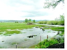
Kurt Hildebrand/Nevada Appeal News Service Floodwaters from the west fork of the Carson River inundate pastureland along Highway 88 in Centerville.
The west fork of the Carson River hopped its banks, closing Mottsville Lane Monday.
Minor flooding was occurring all along the West Fork between where it crosses Highway 88 in Centerville and down to where it meets the East Fork just south of Genoa Lane.
Mottsville was the only road closure after water from the West Fork crossed the road.
"We closed it because there was a little bit of water going across the road, and it was a hazard because people were trying to get around it," said Emergency Management technician Harry Raub.
Besides the closure of Mottsville Lane, there was little official recognition of the West Fork's cresting.
Heavy rainfall Sunday night prompted a flood warning for the West Fork by the National Weather Service, which said it was expected to crest at 14 feet.
Forecasters say minor flooding is expected between Centerville and Genoa. The crest should compare with the Dec. 20, 1981 flooding.
Raub said the Weather Service reported the gauges in Markleeville are going down, indicating that the East Fork of the river was calming.
For the Carson River at Carson City, a river level of 10 feet is considered flood stage. At 8 a.m. Monday, the river was at 5.5 feet, and a maximum height of 8 feet is forecast for this morning.
Localized overbank flood flows begin at about 8 feet in the lowest areas, or 5,240 cubic feet per second. Flood stage is 10 feet.
According to Monday night's flood information from the weather service, the mainstem Carson River will continue to rise through this morning to near 2 feet below flood stage, then fluctuate near that level through this afternoon. Continued snowmelt and possible rain later this week will keep river levels high through the week, but no flooding is expected.
Partly cloudy skies are expected today with a slight chance of rain tonight. More showers are expected Thursday night and during the day on Friday. Snow is expected at the 8,000-foot level today.
South of Carson City, warm weather and an unusually large, melting snowpack caused heavy flooding of the Yosemite Valley floor Monday, cutting off access into the park, officials said.
Traffic was closed until further notice, and visitors were being advised to check weather and road conditions before traveling.
Some campgrounds, parking areas, and lodging facilities were affected.
But rangers said they expected the flood to recede soon.
"We'd be really surprised if it lasts more than 24 hours, but no one can ever predict Mother Nature," said park ranger Adrienne Freeman.
All campgrounds in the East Valley were also closed Monday. Other parts of the park remained open, including areas accessible through Highway 120 West.

Comments
Use the comment form below to begin a discussion about this content.
Sign in to comment