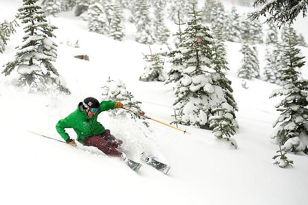
Larry Segal enjoys new snow at Squaw Valley in early December 2014, after the resort received nearly 2 feet of snow up top. It marked the only significant storm of the 2014-15 season.
TAHOE-TRUCKEE — If the forecast pans out, it could be just what the doctor ordered heading into the Christmas holidays.
A major winter storm is expected to hit the greater Truckee-Tahoe region later this week, with several feet of snow possible by Friday morning at high-elevation areas, according to the National Weather Service.
The storm is developing currently in the Gulf of Alaska, according to a Monday statement from NWS, and is “on track to tap into a plume of deep moisture lifting north toward the West Coast starting late Wednesday.”
While it’s too early to predict snowfall totals, “multiple feet of snow are possible from late Wednesday night through Friday morning,” according to NWS, with the most falling above 7,000 feet.
“Questions remain regarding (how) fast snow levels will fall in this storm,” according to NWS. “The differences in the forecast … cast doubt on snow amounts in the Sierra and Northeast California below 7,000 feet. If snow levels fall fast enough, the Sierra valleys below 7,000 feet could see significant snowfall … but if the snow levels fall slower, snowfall amounts will be much less.”
In Carson City, high winds were expected late Wednesday night through Thursday night. Winds are expected to be from the south from 30 to 50 mph with gusts 60 to 70 mph.
Rain is likely Thursday and into Friday, according to the Weather Service. The rain could turn to snow Friday evening.
The forecast, however, was not enough to allow Diamond Peak Ski Resort in Incline Village to maintain its season-opening date of Thursday, Dec. 11. Resort officials Monday announced that date is postponed due to poor coverage at the ski area.
Diamond Peak will announce a new opening date once it has been determined. In a Monday statement, Diamond Peak General Manager Brad Wilson said he “fully anticipates opening well before the holidays.”
According to this week’s forecast, snow levels are likely to start above 7,500 feet and fall through the day Thursday. It figures to be a wet storm, too, with as much as 2 to 4 inches of rain possible across Northeast California and the Northern Sierra, with less than 2 inches in the High Sierra of Mono County.
NWS expects to update the forecast throughout the week as the storm system takes a more firm shape.
The forecast comes after a wet storm dumped roughly 2 feet of snow at higher elevations a week ago, although it provided no coverage at lake level and along the streets of Truckee.

Comments
Use the comment form below to begin a discussion about this content.
Sign in to comment