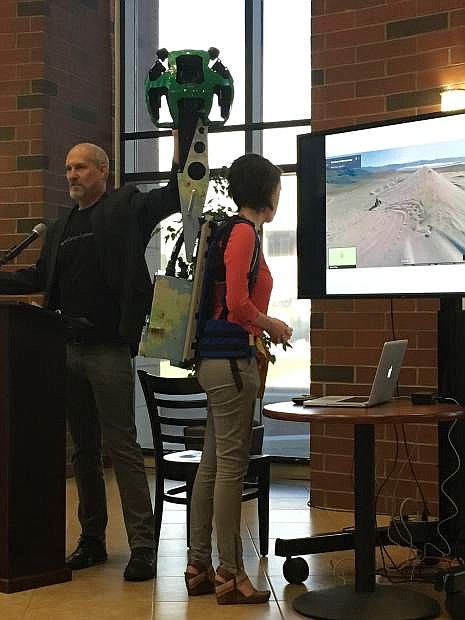
Steve Silverman (left), operations manager Google Trekker, and Sydney Martinez (right), content manager TravelNevada, show how the Google Trekker works.
As part of its mission to effectively promote statewide tourism and enhance the economic vitality of Nevada, TravelNevada became one of the privileged destination marketing organizations to borrow the Google Street View Trekker. The Google Trekker allows images of less traveled areas of Nevada to be seen via Google Maps and the TravelNevada website.
Presenting the outdoor adventure and activities Nevada has to offer via 360-degree images creates exposure to areas of Nevada that may be surprising to people. These areas provide unique, excellent outdoor recreation, which is a huge revenue generating industry.
Claudia Vecchio, director of the Nevada Department of Tourism and Cultural Affairs, explained how outdoor recreation tourism has a huge part in the ecosystem of tourism for Nevada. Everything from purchasing gear to hotel stays and being a patron of local establishments make outdoor adventure a lucrative industry. TravelNevada’s website indicates, “Tourism is the number one industry in Nevada. In 2014, travelers to Nevada spent $62.2 billion, up from $59.4 billion in 2013.”
Today’s technology and ability to access information online, and in the palm of your hand with a cell phone, has warranted products such as Google Maps, which began back in 2005. Google Maps was created to bring some life to a map and allow people to navigate through imagery, explained Susan Cadrecha, communications manager for Street View and Maps at Google. It provided a way for people to immerse themselves in 360-degree views of everything from childhood homes to vacation destinations and jogging routes. This data and imagery has long been collected via the Google Street Car driving around capturing it.
One of the challenges Nevada has faced in marketing their outdoor areas on a visual platform to potential visitors is that many of these areas are not accessible by car. That makes it difficult to capitalize on something like the 360-degree imagery Google can offer other places.
In order to get off road, and bring regions like Nevada to life within the comfort of a person’s home, Google developed the Google Trekker. Vecchio phrased it as a, “tremendous program that allows us to explore our tremendous state of Nevada.” She went on to explain how Nevada has always been at the innovation line with technology and that is part of why the Google Trekker program made sense to show what the state has to offer.
Steve Silverman, operations manager with Google Trekker, explained the process of taking the 350-pounds of equipment, generators and technology housed on the Google Street Car and adapting it for a 40-pound backpack someone can hike with. The final product, Google Trekker, contains knobs on top for GPS location and 15 cameras in a spherical dome that capture images every two and a half seconds. The data is compressed, geotagged and stored on solid-state drives that are part of the backpack. Silverman went on to say, “the images go into Google and that’s where the magic happens.” Meaning, this is where they undergo color corrections, stitching and any necessary edits, before becoming available on Google Street View.
TravelNevada’s partnership with the Google Trekker successfully filmed 22 off-the-grid Nevada locations over the course of three weeks. Some locations included Berlin-Ichthysosaur State Park, Angel Lake and Spencer Hot Springs.
To experience Nevada via the Google Street View Trekker visit TravelNevada or Google Maps, enter the desired location and select Street View.

Comments
Use the comment form below to begin a discussion about this content.
Sign in to comment