The National Weather Service predicts winds will increase Monday night through Tuesday morning. The winds will be from the south at 10 to 20 mph with gusts up to 40 mph this afternoon. Winds tonight are expected 20 to 35 mph with gusts up to 60 mph. Wind prone areas can expect guys up to 80 mph. The Wind Advisory is in effect until 4 p.m. Tuesday.
The wind is expected to make high profile travel conditions hazardous along I580, I80 and Highways 50 and 95.
Power outages also are expected.
•••
CalTrans is turning all truck combinations at I-80 westbound exit 1 in Verdi. There is no estimated re-opening time.
"Due to the lack of truck parking in the Reno area, please plan an alternate route or wait farther east of the Reno area," Caltrans said.
Road controls are in effect for both Kingsbury Grade and Spooner Summit.
Chains or snow tires are required on Kingsbury from the intersection with Highway 50 over Daggett Summit. Similar controls are required over Spooner Summit to Logan Creek, where work is still be done on a rock slide that previous closed the road. Highway 50 remains one lane in each direction there, with no wide loads permitted.
Highway 88 is closed at Kirkwood.
•••
As of 8:30 Monday morning, more than 4-tenths-of-an-inch of rain have been recorded in Carson City. The rain is starting to puddle in low-lying areas of the roads.
The National Weather Service predicts another 12 to 15 hours of rainfall with this atmospheric river.
“Moderate to heavy rain along with snow melt below 7,000 feet will contribute to increasing flows on rivers and streams with an enhanced flood potential through Tuesday morning,” according to the watch as of 7 a.m. Monday. “The highest risk of flooding is along creeks, streams, and poor drainage areas, including the Upper Truckee River in South Lake Tahoe.
“The upper reaches of the Truckee and Carson rivers are forecast to rise to near monitor stage tonight into Tuesday, but at this time are expected to remain below flood stage.”
Travel over the Sierra and or to Lake Tahoe today is advised. Chain and or snow tires are required on:
Spooner Summit
Mt Rose Highway
Kingsbury Grade
and in the Donner Summit area
Check current road conditions before driving.
•••
Another atmospheric river is expected to bring 1.5 to 2 inches of rain to Carson City on Monday.
The storm is expected to drop 8-12 inches of snow of Spooner but 36-48 inches on Mt. Rose. Dayton could receive up to 1.5 inches of rain.
That much rain plus already saturated soils as resulted in a flood watch from 10 a.m. Monday until 4 p.m. Tuesday.
The NWS highly discourages traveling across the Sierra during the storm as travel will be greatly impacted by the storm.
The National Weather Service in Reno says this storm will produce strong winds and possible rock and mudslides.
"In addition, heavy snow and strong winds at upper elevations will create whiteout conditions and increasing avalanche hazards. Winds will also be very strong at times with Sierra ridge winds in excess of 150 mph possible," NWS-Reno said.
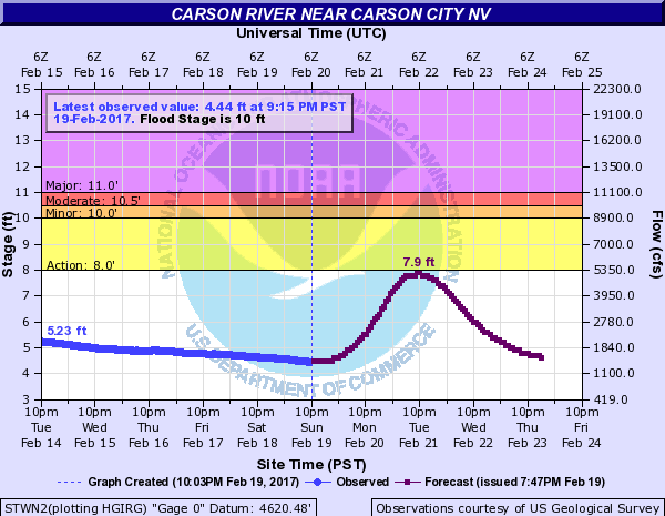
The good news for the Carson River is the river is forecast to not reach major flood stage.
 Winds will increase late Monday morning and continue through Tuesday afternoon. The NWS says the strongest winds — gusting near 70 mph — will occur Monday afternoon through Tuesday morning.
Winds will be from the south to southwest from 20 to 35 mph.
For up to date flooding in Carson City, check: http://carsoncity.maps.arcgis.com/apps/webappviewer/index.html?id=56d7e396d24845519638c1a0ca08309c
Winds will increase late Monday morning and continue through Tuesday afternoon. The NWS says the strongest winds — gusting near 70 mph — will occur Monday afternoon through Tuesday morning.
Winds will be from the south to southwest from 20 to 35 mph.
For up to date flooding in Carson City, check: http://carsoncity.maps.arcgis.com/apps/webappviewer/index.html?id=56d7e396d24845519638c1a0ca08309c
Are you prepared for flooding?
University of Nevada Cooperative Extension director Lindsay Chichester offers these tips about flooding.
There has been a lot of talk this week about the 1997 flood. Twenty years ago, on New Year’s Eve Day (1996) my dad and I went goose hunting. We had set out our decoys and had a good early morning hunt, however, it started raining so we packed everything up, leaving the bags of decoys in a dry irrigation ditch. The next day we went back to get the decoys, as it was still raining. Three days later the rain finally stopped, but left massive destruction in its wake. I will never forget that flood and all of the unfortunate circumstances of those in its path.
Now, as talk is recirculating about another flood, it may be time to familiarize ourselves with some good tips during floods. Information below has come from the Red Cross, FEMA, and the National Weather Service.
First, let’s talk terminology. A flood watch means flooding is possible in your area. You should be prepared to move to higher ground upon short notice. A flood warning means a flood is occurring or is about to occur. If advised to evacuate, do so immediately.
But do I really have to leave my home? If the danger to you is significant, local authorities may issue an evacuation notice to alert residents in an area that flooding will be or is occurring and it’s important to leave the area. Evacuation orders vary by community and by state, and may range from voluntary to mandatory. When authorities issue a mandatory evacuation notice, leave the area immediately. If you have pets take them with you. If you can’t take them with you make arrangements to board them at a facility well away from flood danger. Keep in mind the Five Ps of Evacuation: people, prescriptions, paper, personal needs, and priceless items (these are more clearly defined below).
Before a flood:
Water: At least a three-day supply (one gallon per person per day and extra if you have pets)
Food: At least a three-day supply of non-perishable, easy-to-prepare foods
Medications: At least a seven-day supply
Medical items: Hearing aids and batteries, glasses, contact lenses, syringes, canes or other walking assistance tools, items for people with disabilities
First aid kit
Flashlight with extra batteries
Rubber boots and rubber gloves
Copies of personal documents (medication lists, important medical information, deed/lease to home, birth and/or marriage certificates, insurance policies, etc.)
Cell phones and chargers
Family and emergency contact information
Extra cash
Extra blankets, clothing, and shoes
Baby supplies (bottles, formula, baby food, diapers)
Pet supplies (collar, leash, ID, food, water, carrier, bowl, blankets, toys)
Extra sets of vehicle and house keys
Priceless items or valuables
Rain gear
Camera for photos of damage
A NOAA weather radio which receives broadcast alerts directly from the National Weather Service
During a flood:
Listen to the TV and/or radio for flood warnings and reports of flooding
Be prepared in case there’s a power outage, have electronic devices charged
Take advantage of sandbags if your home/business is in a flood prone area — be prepared, as these take longer to fill than you might think
If you have a basement, make sure your sump pump is working, consider a backup battery operated one if necessary
Clear debris from gutters or downspouts
Cautiously clear small items out of waterways, anything bigger than a tumbleweed should be removed by an emergency service person
Anchor any fuel tanks and outdoor furniture
Move important documents and valuables to a safe place
Be prepared to evacuate at a moment’s notice
When a flood or flash flood warning is issued for your area, head for higher ground and stay there
Don’t try to walk in flood waters, just six inches is enough to knock you down
Don’t try to cross a flooded road, turn around and find an alternative route. Most cars can be swept away by less than two feet of water
Keep children out of the water
Be especially cautious at night when it’s harder to recognize potential dangers
Know your evacuation routes (several may need to be identified) and have a place to stay
Ensure your vehicle has a full tank of gas and is ready to go if you need to leave an area quickly
If you don’t have a place to go, contact the city to determine where evacuation shelters are located
Establish a communication plan with family — determine ahead of time where you will meet or go if you should get separated
Use text messaging or social media to let friends and family know you’re safe
If you should happen to get trapped in a building, vehicle, or outdoors during a flood, get to the highest spot you can and try to signal or call for help.
After a flood:
Only return home when officials have declared the area safe
Shut off utilities until it can be determined they don’t pose a risk
Use flashlights, not lanterns, torches, or matches to examine buildings, as open flames may cause a fire or explosion if gases have been leaking
Before entering your home, look for loose power lines, damaged gas lines, foundation cracks, or other damage
If you smell natural or propane gas or hear a hissing noise, leave immediately and call the fire department
If parts of your home are collapsed or damaged, approach carefully
During cleanup, wear protective clothing, rubber gloves, and rubber boots
Be especially cautious of mold, asbestos, or lead paint contamination
If food or water have come into contact with floodwater, discard these items
Work with your insurance company if you have flood insurance
Let people know you are safe
Unfortunately we cannot prevent floods, but we can prepare for them. By having a plan in place and communicating that with people closest to you will help ensure peace of mind and safety.
Lindsay Chichester is an Extension Educator with University of Nevada Cooperative Extension.

Comments
Use the comment form below to begin a discussion about this content.
Sign in to comment