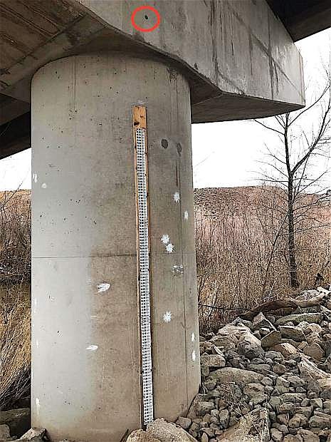
A weather staff is located underneath the bridge off of North Deer Run Road. The marker for the flood of 1997's is a circle and can be seen above the staff.
Hydrotechs of the U.S. Geological Survey’s Nevada Water Science Center braved the cold Wednesday afternoon to measure the height of the Carson River, by tossing an acoustic doppler into the water to collect data.
They conducted measurements from the bridge on North Deer Run Road and near the Northern Nevada Correctional Center. In wake of the upcoming set of storms, the height of the river reached more than what they expected, said Hydrotech Joe Joyner.
And there’s no doubt it’ll rise.
“Tremendous flows clean out debris in the river,” he said. “But regardless of storms, we have to check these rivers every six weeks. Even though measurements are ideal, things like torn up beaver dams and moss could change the riffle in the river, in which the gage would collect immense height numbers.”
Another way to help determine height, Joyner said, is to observe the debris piles in the water.
Underneath the bridge along Deer Run Road is a staff drilled into the concrete of the bridge’s pillar.
It looks like a large ruler — technically, it’s one.
After every flood, hydrotechs use the massive ruler for measurement of the water’s height. The most recent flood from last week reached 16.40 inches.
But as for the flood in 1997, the height went well above and beyond the chart. Joyner placed a green dot of where the water reached that year, almost touching the bottom of the road.
Joyner said the flood of 1997 destroyed many of the streamgages in the area, which helps USGS teams conduct these measurements. But when they measured the Truckee River in Reno on Tuesday, their oldest streamgage of 110 years survived.
Hyrdotech teams also found the Truckee River had dropped, but is expected to rise again because of the storms.
Joyner and the team didn’t end the day on Deer Run Road; they gathered more information from the Carson River at Fort Churchill and to the Lahontan Reservoir. But since the results of the approaching storms are expected to be somewhat drastic, the USGS teams are required to stay within their region for safety.
The plan was to continue measurements in Genoa, followed by the creeks in Ely. Measurement tests take about 30-40 minutes to complete, per location.
Data from measurement tests are sent to the organization’s National Groundwater and Streamflow Information Program, where federal agencies such as the National Weather Service can use the information to address warnings and other natural hazard updates to the public, essential to monitoring Nevada’s flood risks. Eventually, the results are posted on the USGS website for the public at waterwatch.usgs.gov.

Comments
Use the comment form below to begin a discussion about this content.
Sign in to comment