RENO, Nev. — The Natural Resources Conservation Service decided to wait out recent storms so it could conduct its snow survey on March 5 at the Mt. Rose SNOTEL site.
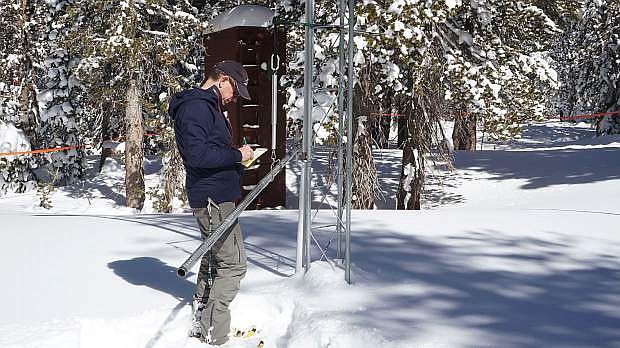
NRCS Hydrologist Jeff Anderson measured the snowpack by shoving a hollow metal pole through the snow and down to ground level.
“... We’re seeing about 86 inches of snow depth, and that snow, if you melted it down, would have about 22.5 inches of water content in it, and that’s 67 percent median for this day,” he reported. “So, almost 70 percent, which is up about 12 percent since before this storm started. We saw a nice increase from this storm.”
The snow survey was originally scheduled to take place March 1 at the SNOTEL site, which is located near the Mt. Rose Highway rest area.
However, a major weather system blew through the Sierra last week, bringing more than 5 feet of snow at Lake Tahoe ski resorts between March 1-3, and plenty of wintry conditions across the region.
It the biggest storm western Nevada had seen since November, and while that storm produced a lot of rain, this past storm yielded the highest snowpack, Anderson said.
Lake Tahoe Basin-wide, there was a 12 percent bump in snowpack. The Carson Basin saw a 16 percent increase, from 40 percent to now 56 percent of the median snowpack, which is still the 10th lowest since 1981.
“Anytime you have a big storm that starts right on March 1 ... you’re setting yourself up for the potential for a Miracle March,” Anderson said about outlook for the rest of March. “In order to get there, we would need two or maybe even three more storms like the one we just had.
“So it would have to be a real sustained stormy month. Hopefully, the storms deliver and we’ll see a nice increase.”
This year is on a better trajectory than other winters, especially with this past storm, which was predicted to be one of the biggest storms of this season.
“If we can keep the storms coming, certainly we’ll see the biggest month that we’ve seen this year, and hopefully we’ll get back to that ‘Miracle March’ status that we saw in 1991, where the snowpack went from 20 percent to 80 percent in just one month,” Anderson said.
Chad Blanchard, Federal Water Master for the Carson-Truckee rivers, was also on hand for the March 5 snowpack survey. He discussed current river levels and the status of the region’s water supply.
“The flood control levels are as high as we can be at the reservoirs at this point,” he said. “We were happy not only to have the precipitation, but to (also) have it fall as snow, because if it falls as rain and runs off right now, we can’t capture it.”
At this point, Blanchard said, it doesn’t look regional reservoirs can store much more water until April 10. This is a great sign for water supply.
NRCS installs, operates and maintains an extensive automated network of SNOTEL weather stations to collect snowpack and related climatic data in the Western United States.
In addition to measuring the snowpack’s water content, SNOTEL sites also measure annual precipitation, air temperature, snow depth and soil moisture.

Comments
Use the comment form below to begin a discussion about this content.
Sign in to comment