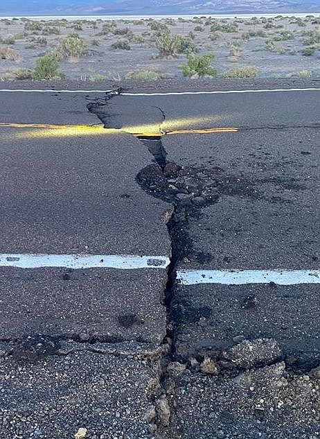
Cracks on U.S. 95 at mile marker 89 in Esmeralda County. Traffic may be re-routed. Expect delays.
UPDATE, 2:11 p.m., Friday, May 15
The Nevada Highway Patrol has reported via Twitter that U.S. 95 is now open.
UPDATE, 9:37 A.M. FRIDAY, MAY 15
The Nevada Department of Transportation said Friday morning’s earthquake caused minor pavement damage to a half-mile section of U.S. Highway 95, north of the U.S. Route 6 junction in Tonopah. Most of the cracked areas have a minor lift that, as a temporary fix, will be shaved to minimize roadway surface bumps until a full repair can be scheduled.
NDOT has temporarily closed U.S. Highway 95 between the U.S. Route 6 junction and U.S. Highway 360, with traffic being detoured. The temporary closure will remain in place until 5 p.m., Friday, May 15.
INITIAL STORY
A magnitude 6.5 earthquake struck 37 miles west of Tonopah at 4:03 a.m. Friday morning followed by a series of aftershocks felt throughout the region.
Information from both the U.S. Geological Survey and the Nevada Seismological Lab at the University of Nevada, Reno reported at least 15 aftershocks through 6:01 a.m. Originally, the USGS registered the earthquake as a magnitude 6.4 but upgraded it to a 6.5.
At least 15 aftershocks are still happening, including a 4.9, 5.1 and 4.7 quakes.
Both the Mineral and Nye County Sheriff's Offices report U.S. 95 has been damaged and is closed while deputies assess the damage to the major north-south highway, said Nye County Capt. David Boruchowitz in an email to the Lahontan Valley News.
Other reports said groceries have been knocked off the shelves at several Tonopah stores.
People from as far east as Salt Lake City, Utah, to near the Mexico border reported a strong rolling earthquake that woke thousands of people up from their sleep. Residents in western Nevada flooded law enforcement with calls after the first quake hit.
The Mineral County Sheriff’s Office reports no damage in the small towns of Luning and Mina, which are near the major earthquake’s epicenter. The two towns are south of Hawthorne on U.S. Highway 95. A call has been made to the Nye County Sheriff’s Office to check on any reported damage in the Tonopah area.
Kathleen Leonard Rodegeb said on the Lahontan Valley News' Facebook page she felt several rolling sensations with Friday’s earthquake.
“Then a strong force from the west tried to move my house to the east. It tried three strong pushes spaced seconds apart. It made me head for the door frame and look for the quickest exit. Then I packed a bag in case I need to head for the hills, so to speak. A little later, more rolling motions.”
Other residents from Battle Mountain to Minden said they felt a strong jolt.
Denielle Hartzell commented on the LVN Facebook page.
“Bed took a long time to stop rolling. Woke us up out of a dead sleep. Lived in California since over 20 years and hubby and I both said we never felt one like that.”
Churchill County is no stranger to earthquakes. A series of tremblors both east near Fairview Peak and northeast of Fallon in 1954 caused considerable damage in the region. The quakes ranged from a magnitude 6.6 to 7.1
The strongest earthquake in Nevada during the past 25 years up until this morning occurred in Wells, a small community between Elko and Wendover. On February 21, 2008, a magnitude 6.0 earthquake struck the city, causing to damage to about 700 structures
The Nevada Seismological Laboratory operates a network of about 150 real-time seismograph stations throughout the region providing earthquake information to Nevada citizens, the USGS, and local and state officials. For information or to track earthquakes, go to http://www.seismo.unr.edu/Earthquake or to the USGS site, https://earthquake.usgs.gov/earthquakes/map/
Northern Nevada and the eastern side of the Sierra Nevada have been active with a number of earthquakes and aftershocks since March when a 4.5 magnitude tremor shook the Prison Hill area southeast of Carson City, and dozens of aftershocks continued for several days.
The strongest aftershock registered a magnitude 3.0.
In April, a small earthquake and a series of aftershocks occurred near the Mono Lake-Lee Vining area of eastern Callfiornia near the Sierra Nevada range, but they caused no significant damage. The Nevada-Eastern California border region has a history of large, damaging earthquakes. Two major earthquakes with magnitudes of 6.4 and 7.1 and series of aftershocks near Ridgecrest, Calif., over the Fourth of July weekend in 2019 not only disrupted everyday life for the town and surrounding area but also ceased most operations at the massive Naval Air Weapons Station China Lake 325 miles southwest of Fallon.
| Magnitude | 6.4 |
| Date-Time | 15 May 2020 11:03:27 UTC15 May 2020 04:03:27 near epicenter15 May 2020 03:03:27 standard time in your timezone |
| Location | 38.169N 117.879W |
| Depth | 7 km |
| Distances | 31.8 km (19.7 mi) SE of Mina, Nevada181.0 km (112.2 mi) ESE of Gardnerville Ranchos, Nevada198.1 km (122.8 mi) SE of Carson City, Nevada199.3 km (123.6 mi) SE of Fernley, Nevada202.2 km (125.4 mi) ESE of South Lake Tahoe, California |
| Location Uncertainty | Horizontal: 0.0 km; Vertical 16.8 km |
| Parameters | Nph = 16; Dmin = 38.6 km; Rmss = 0.21 seconds; Gp = 56° Version = 725272 |
| Event ID | nn 00725272 |

Comments
Use the comment form below to begin a discussion about this content.
Sign in to comment