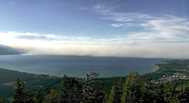
The Nevada Seismological Laboratory in the College of Science is building out its earthquake monitoring network with high-definition cameras on their wireless, digital microwave communications network. This shows a view from South Lake Tahoe looking northwest at smoke from the King Fire west of Lake Tahoe in September.
The success of the pilot program for fire cameras at Lake Tahoe has prompted the University of Nevada, Reno’s Nevada Seismological Laboratory to pursue funding to build out its fire camera network that rings the majestic mile-high lake.
“We’ve seen the system avert potentially large fires this summer at Tahoe, even with its minimal presence,” Graham Kent, director of the Nevada Seismological Laboratory, said of the prototype system with its four cameras. “It makes sense to build this system out now to help protect the basin from devastating fires.”
The Nevada Seismological Laboratory is launching the AlertTAHOE campaign to raise $2 million in private donations to place additional cameras, the associated telemetry infrastructure and a user friendly web portal at 15 more locations. The equipment will be available for use by emergency response personnel and viewing by the interested public.
The fire-camera system project will be funded through private and public money, and built on the backbone of the Seismological Lab’s earthquake monitoring network, which features private high-speed internet connectivity capable of transmitting seismic, environmental and climate data in addiiton to the live streaming high definition cameras.
With adequate funding, it will take approximately two years to build out the project. Operational costs over the next decade have been included in the target fundraising goal.
“AlertTAHOE is a challenge to the greater Tahoe community — its residents, visitors, leaders and the business community — to invest in the expansion of this one-of-a-kind fire camera system,” Kent said. “The fire-camera system is built upon an emergency information platform already in use for earthquake monitoring and response.”
The urgency of this project is dramatically heightened by a prolonged drought and recent firestorms such as the Rim and King fires. The total 10-year cost of this fully expanded system is 1.25 percent of the losses incurred during the 2007 Angora Ridge fire. This significant Tahoe fire was only 1 percent and 3 percent, respectively, of the area covered by the nearby devastating Rim and King fires in 2013 and 2014.
All funding received through this fire camera program will be invested directly in the Tahoe Basin solely for this program.
Gifts may be made online at: http://alerttahoe.seismo.unr.edu.
Kent has met with Tahoe planning and regulation organizations about the system and the fundraising effort and has received positive feedback.
“I met with the Tahoe regional fire chiefs and a representative of Care Flight the other day at Squaw,” Kent said. “They were really excited. I’ve now heard about a dozen applications, mostly health and life safety, brought up that we did not envision. This is a very exciting paradigm shift in disaster response for the Tahoe Basin.”
Since this a private network, it’s not susceptible to increased public Internet traffic following high-impact catastrophic events such as earthquakes, floods, and fires.
“The fire cameras, and especially the Internet backbone and network that supports it, are a valuable tool for fire officials as well as Tahoe researchers who are studying the lake’s environment,” Kent said. “Fire agencies have been monitoring the region with our cameras for more than a year now.”
The fire officials are able to control the cameras remotely from their computers and have been tracking controlled burns around the basin this fall. The network cameras give real-time 360-degree views and they pan, tilt and zoom for greater detail. They are a critical help in spotting wildfires as early as possible so fire crews can respond before the fire is out of control.
For example, on the evening of Aug. 9, the university’s Snow Valley Peak camera on the east shore was being used by Mac Heller of the Lake Tahoe Basin Management Unit of the U.S. Forest Service to scan the area, which had been getting lightning for several days. He saw thin wisps of smoke in the Spooner Summit area and contacted the Forest Service’s dispatch center in Camino, Calif.
“Once the suppression resources were on scene, they reported it as a half an acre,” Heller said. “Who knows how big the Spooner fire would have been if it had been reported later or the next day or so.”
To see some of the video downloaded from the fire camera network go to https://www.youtube.com/user/nvseismolab. To see the public interface with views from the cameras, and for more information about the network, visit http://alerttahoe.seismo.unr.edu. Since recent storms have blanketed the Sierra with snow, some cameras may be offline for maintenance.

Comments
Use the comment form below to begin a discussion about this content.
Sign in to comment