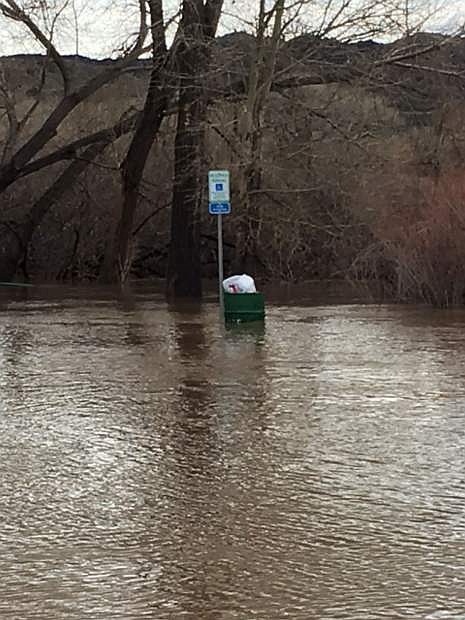
Morgan Mill Road, which is closed due to flooding, includes a natural park with boat ramp, benches, picnic tables and is a trailhead for both the Aquatic Trail and the Empire Ranch Trail.
A mix of snow and rain is forecast until Thursday in Carson City and a flood advisory throughout the region has been extended until 10:30 a.m. Wednesday.
On Tuesday, Carson City assembled its damage assessment teams consisting of personnel from Public Works, the Fire Department and Parks, Recreation and Open Space, according to Stacey Belt, deputy emergency manager.
The teams will be reviewing city infrastructure, including roads, bridges, parks and trails for as long as it takes, said Belt.
“Carson City is working hard to have preliminary damage mapping and estimates of cost by the end of the week,” said Belt.
Daniel Rotter, Carson City engineer, said the state has asked for some initial estimates in case it needs to seek assistance from Federal Emergency Management Agency.
Continued rain on Tuesday brought a few new problems, but nothing major.
In the afternoon, there was a report of a downed tree on 5th Street, between Mary Street and Richmond Avenue, and a partial wash out at Canyon and Knoll drives in the King’s Canyon area.
Plugged culverts were causing some flooding on Red’s Grade in Lakeview and on Arrowhead Drive.
Curry Street between Lake Glen Drive and Rhodes Street, where water flowing down the hill was being diverted away from local businesses, remains closed indefinitely. Morgan Mill Road between Empire Ranch and Deer Run roads and Fermi Road off Goni Road are still closed due to water over the roadways.
Downtown Carson City remained free of flooding, thanks to hard-working crews and a few changes made during downtown construction work last year, said Rotter.
“The crews were on top of it quick. They did really solid work,” he said.
When Carson Street was repaved last year, utility work included adding more inlets, or road grates, and the replacement of 12-inch culverts with 15-inch pipes.
In addition, Carson Street was repaved without a crown, or high point in the middle, and now slopes to the east so water doesn’t pool on the west side of the street, said Rotter.
The National Weather Service says there’s a chance of snow accumulation here between 1 to 3 inches in the next couple days.
The Carson River near Prison Hill reached its peak at just over 11 feet at about 7 a.m. Tuesday and by 3 p.m. had dropped to 10.4 feet and was projected to dip to 5 feet by midday Thursday.
The city closed its Emergency Management Operations center 5 p.m. on Monday.
More worrisome was Lyon County where the Carson River was expected to crest overnight.
On Tuesday, 96 hand crews from the Nevada Department of Forestry were sandbagging in the Harbor/Marina Drive area in Dayton and moving east. Road crews built a temporary fix on Dayton Toll Road for residents to get out.
NV Energy reported at 11 a.m. Tuesday that about 4,000 customers in Lyon County were without power and Lyon County Emergency Management opened a temporary shelter at Dayton High School midday.
Six Mile Canyon, between Highway 50 in Lyon County and Virginia City, will be closed for two to three weeks.
Roads in Douglas County, where Highway 395 had been closed southbound, started to clear up.
By midday, the county reported all roads were open except Kingsbury Grade.
In Storey County, a water line in Lockwood was fixed but a boil water order stays in effect until Thursday. State Route 342 Gold Hill was closed except to local traffic southbound from Virginia City.
An avalanche warning in the mountains is in effect until 7 a.m. today. The Squaw Valley Fire Department closed Alpine Meadows Road midday Tuesday due to an avalanche and much of Mt. Rose Highway remained closed due to extreme weather.
Snow totals over a 24-hour period reached 40 inches in Soda Springs, 38 inches at Mt. Rose, 25 inches in Incline Village and 10 inches in South Lake Tahoe by Tuesday morning, according to NWS.
The silver lining in the week of storms is the positive impact on the area’s water supply.
In the Carson River basin, the snow water equivalent is now 155 percent of median while the year-to-date precipitation is 178 percent of average, according to Natural Resources Conservation Service’ SNOTEL data.
Lake Tahoe is 146 percent of median snow water equivalent and 218 percent of average precipitation.
The dry Walker River, Upper Humboldt River and Lower Humboldt River basins are getting some much needed relief, too.
The Walker River basin’s is snow water equivalent is now at 164 percent of median and its precipitation is at 194 percent of average.
In the Upper Humboldt, those numbers are 162 percent and 153 percent and in the Lower Humboldt they are 148 percent and 153 percent, respectively.

Comments
Use the comment form below to begin a discussion about this content.
Sign in to comment