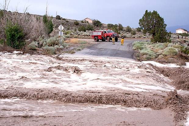
Fish Springs Volunteer Fire Department first responders block Jo Lane on Sunday.
Sunday’s deluge was a once-in-a-century occurrence, Douglas County officials said Thursday.
“The initial analysis places this storm at a 100-year, two-hour storm, essentially meaning that the intensity of rainfall had a 1 percent chance of being exceeded or that it was 99 percent greater than typical storms,” officials said.
The National Weather Service reported 1.21 inches of rain fell at the base of Hot Springs Mountain in less than two hours on Sunday.
That water rushed down a wash on the south side of the mountains sending water rushing into homes along the base.
Residents in Buckbrush Estates reported mud wiped out their yard, filled pools, entered garages and otherwise damaged their homes.
Homes along Long Drive in the Sunridge Golf Course area also sustained damage in the flood.
Despite the damage, county officials said it didn’t rise to the level of a national emergency.
“There is no argument that the storm created problems for the public as far as drainage ditches, debris on the roadway, widespread damage to homeowner’s landscaping and, worst of all, mud and debris entering homes and garages but, this did not constitute a widespread emergency,” said Douglas County Interim Manager Larry Werner, former Carson City city manager. “The storm event that occurred Sunday, while creating major issues in certain areas of the county, simply did not rise to the level of a national emergency.”
East Fork Fire District Chief Tod Carlini, who also serves as Douglas County Emergency Manager said county and state emergency officials discussed the issue.
“As significant as this event was, state officials were in agreement with local officials that the event would not qualify for FEMA assistance,” said Carlini, “In order for disaster declarations to be considered, certain financial loss thresholds have to be met. This event did not meet those thresholds. Flooding of any type can be just as devastating as a fire.”
On Thursday, Douglas County crews were working with private contractors to clean up mud and dirt on public property.
Flood insurance and FEMA Flood mapping has been a topic for the public when looking for financial assistance from damages incurred by flooding. The FEMA flood mapping is generally for the use of lending institutions in the process of providing loans. Where certain levels of flooding are indicated on a FEMA map, flood insurance may be required.
“The county’s involvement on the FEMA mapping was to review the adequacy of the maps and to address accuracy.” Werner said. “Once the map is adopted, the matter of flood insurance, whether the subject property is shown in a flood zone or not, is between the homeowner and their insurance company. The main role of the county is to review building plans and assure that certain building standards are adhered to to meet flood zone requirements in the building of a structure and the county is not involved in whether flood insurance should or should not be issued.”
The drainage facilities in the areas affected by the storm were overwhelmed, well beyond the design capacities according to Douglas County Planning and Engineering Department.
The county’s facilities are designed to carry specific design storms such as a 25-year peak runoff which is usually generated by a 6-24 hour storm. With a 100-year storm over such a short period of time facilities were quickly overwhelmed.

Comments
Use the comment form below to begin a discussion about this content.
Sign in to comment