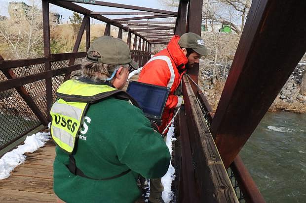
On Tuesday at John Champion Park in Reno, USGS Hydrotechs Emil Stockton and Kristopher Ross are measuring the Truckee River with an ADCP machine to collect volume of water, and post results on the website.
Despite heavy rainfall and snow Truckee River received the last two weeks, water levels dropped tremendously although it’s still at a high level for this time of year, said the U.S. Geological Survey’s Nevada Water Science Center on Tuesday.
After a flood occurs, scientists and field technician crews of USGS are required to collect discharge measurements in areas affected from the flood, such as the Truckee River at John Champion Park, on Kuenzli Street in Reno. The data is sent to the organization’s National Groundwater and Streamflow Information Program, where federal agencies such as the National Weather Service can use the information to address warnings and other natural hazard updates to the public, essential to monitoring Nevada’s flood risks.
After performing an inspection to ensure the gage is collecting volume numbers accurately and verifying peaks, crews found the Truckee River to be significantly below flood stage at 5.82 feet.
During the storm on Jan. 10, it reached 10 feet. Looking at a bigger picture, the Truckee River reached at a peak of 14.94 feet in 1997, followed by 13.38 feet during the storm in 2005.
Although the peak in this year’s storm reached 12.4 inches, Hydrotech Joe Joyner said it’s still too early to compare. “This storm system isn’t over yet,” he said. “Right now there’s no determination to compare if this flood will be bigger than 2005.”
Hydrotechs also found the streamgage is operating normal and in good condition. This is great news as the area lost at least six gages during the flood storm in 1997, said Joyner.
The site is substantial for inspection, as it’s the area’s oldest streamgage to survive high floods. The permanent station has been in operation since 1906; the structure helps monitor how high the waters rise by measuring cubic feet per second.
Hydrotechs said the Truckee River also is carrying a great amount of water to Pyramid Lake, which is probably making fish happy. The peak levels at Mogul also recorded at a high water level from the storms.
“Everything is relatively successful,” said Hydrotech Melanie Letalik. “It’s also reassuring to see the debris line is coordinating as well.”
Today, the USGS teams are testing streamgages in Carson City and Genoa. Joyner said he’s more interested in Genoa’s results since the Genoa Lakes Golf Club & Resort was flooded.
“We’re hoping to see similar results in the Carson River,” he said. “We want high water marks with the gage readings.”
The data USGS teams collect from local rivers also are posted publicly online for curious minds to observe. Visit waterwatch.usgs.gov for updates on the Carson River.

Comments
Use the comment form below to begin a discussion about this content.
Sign in to comment