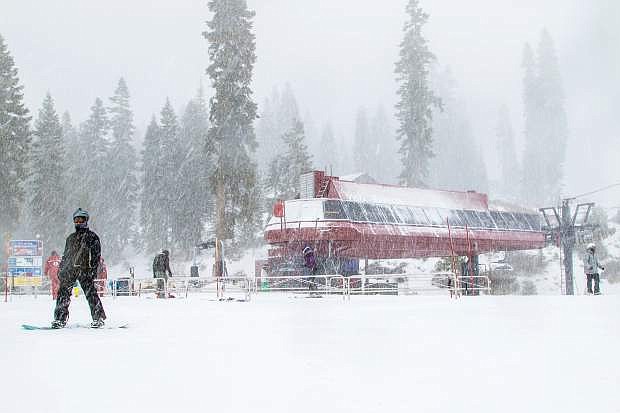
A Wednesday, Nov. 24, storm drops a fresh coat of snow on Northstar California Resort. More snow is expected for the Tahoe Basin this week.
SOUTH LAKE TAHOE — Weather forecasters are calling for another winter storm to pass through the Tahoe Basin starting Thursday afternoon and into Friday morning. The system could once again bring travel delays to the region with snowfall amounts comparable to last week’s storm.
“It’s pretty similar,” Reno-based National Weather Service forecaster Zach Tolby said, comparing the two weather patterns. “It’s a little warmer, but not a lot.”
Forecasters are calling for 1 to 3 inches at lake level with around 3 to 8 inches at higher elevations. Some of the higher peaks along the Sierra Crest could see up to a foot of new snow.
In Carson City, a wind advisory is in effect from 9 a.m. to 6 p.m. Thursday. Winds are expected to be from the south to southwest at 20 to 35 mph with gusts up to 50 mph. The winds are expected to impact travel. While the storm is expected to produce snow in the mountains, the valleys are expected to see rain.
“We’re definitely expecting travel impacts on Thursday, especially in the late afternoon and early evening,” Tolby said.
Wind could once again lead to turbulent conditions on the lake as well.
OpenSnow.com Tahoe forecaster Bryan Allegretto said the snow will be heavier than the previous storm, consistent with more seasonal snow conditions.
“It’s not going to be that ridiculous fluffy powder,” Allegretto said, comparing it to previous systems.
And while early season storms have shown promise — especially when compared to recent snow years — Allegretto is quick to point out the region is still below average in regard to precipitation.
As of Tuesday afternoon U.S. Department of Agriculture snow-water equivalent measuring stations (Snotel) were reporting between 65 and 70 percent of average for this time of year for the South Lake Tahoe Region.
“We’re way behind for the month and for the year,” Allegretto said. “It’s amazing the perception of the snowfall, if it’s snowing at lake level.”
By contrast to the last four winters, however, Tolby said, “We’ve had a good start.”
He described the snowpack as closer to average.
Updated Nevada road conditions, from winter road closures to traffic and road incident information, are available by dialing “511” or logging on to nvroads.com before driving. Drivers can also check nevadadot.com to view live traffic cameras. Winter driving safety tips are available at nevadadot.com/winter.

Comments
Use the comment form below to begin a discussion about this content.
Sign in to comment