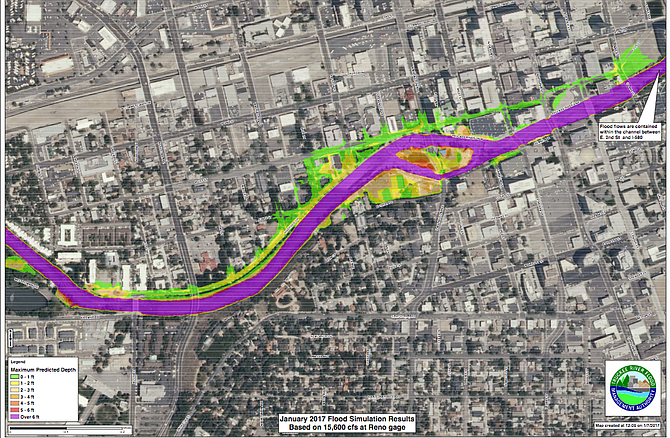
Links to updated flood simulation maps for northwestern Nevada can be found here: http://truckeeflood.us/349/january_2017_flood_watch.html
Washoe County Emergency Manager Aaron Kenneston reminded officials from the various agencies today that the region is still in Flood Alert Stage. The Regional Emergency Operations Center has been activated for the duration of the event.
According to the National Weather Service in Reno, there is a Flood Warning in effect from approximately 1 p.m. on Sunday to approximately 11 p.m. Monday. Anticipated peak flooding times will be between 5-8 p.m. on Sunday in Reno, and 3-7 a.m. on Monday in Sparks.
Residents are advised to stay home, if possible, and to avoid nonessential travel in order to stay safe and with respect to emergency operations. Residents should be cautious that flood waters could be sewer contaminated. View Washoe County Health District Flood Health & Safety Information.
Washoe County Sheriff Chuck Allen said he has increased staffing throughout this event. However, response time could be delayed due to weather conditions and increased call volume. There will be several road closures.
“My advice to residents is to stay home if it all possible,” Sheriff Allen said. “Stay put, stay safe, stay away from water and out of the backcountry. It is also very important to stay up to date on the latest weather and road conditions.”
Wooster High School and Sparks High School have been activated as the primary regional shelters as of today at noon. People and small animals are welcome at these locations.
For large livestock animals, residents should use the Reno-Sparks Livestock Events Center (1350 N. Wells Avenue in Reno). They can enter at Gate 6 off of Sutro Street.
Sandbag information is available at the following links:
Please be advised that all Washoe County School District schools are canceled for Monday, January 9, 2017 due to predicted severe and dangerous weather conditions. The school district will review weather implications for Incline Village schools on Sunday, January 8, 2017 and will contact Incline families if schools are safely able to open there. Visit washoeschools.net for further updates.
In anticipation of significant flooding, several downtown Reno buildings will be closed on Monday morning, including the three courts: Reno Municipal Court, Second Judicial District Court and Reno Justice Court.
Alternatively, the Jan Evans Juvenile Justice Center will remain open. Veterans Court will be held at Jan Evans Juvenile Justice Center at 650 Ferrari-McLeod Blvd., Reno 89512. Veterans Court participants should arrive at 9:30 a.m. Temporary Protection Order (TPO) applicants may go to the Jan Evans Juvenile Justice Center at Ferrari-McLeod Blvd between 9 a.m. and 3 p.m. to complete a TPO application or call 775-328-3468 for assistance. January 9 will be a non-judicial day for purposes of calculating filing deadlines.
The Downtown Reno Library will be closed, along with several businesses. Because the flooding is likely to occur through Monday, it is important to understand that flood-prone facilities will likely be inaccessible on Monday morning.
Arlington and Sierra bridges are open with restrictions. Lake Street bridge will remain closed through the flood event.
From approximately 1 p.m. tomorrow to 6 a.m on Monday, the White Fir Street community in northwest Reno could potentially have no access to the bridge over the Truckee River. They should be advised to plan accordingly.
The Sparks industrial area will be severely impacted. For more information on how the City of Sparks is preparing for the storm, go to cityofsparks.us.
No Regional Transportation Commission routes are inoperable at this time, but RTC is assessing based on changing conditions. Riders should plan for possible delays due to road conditions.
The Reno-Tahoe Airport Authority leadership team will be manning the airport emergency operation center starting tomorrow afternoon. Airport officials have been working in close concert with the National Weather Service and the Washoe County emergency management team for the past 10 days planning for the storm. The airport has communicated to all the airlines and tenants that there is a flood risk. The airport has filled 2,000 sandbags and have more if needed.
How to get information:
Call 2-1-1 if you have non-emergency questions, follow the hashtag #NVFlood17 on social media, or use the specific communications channels for each entity described below. For more information, visitwashoecounty.us.
*Call 9-1-1 in an emergency situation.
Official hashtag:
Media and the public are encouraged to ask questions and share information on social media by using the hashtag #NVFlood17.

Comments
Use the comment form below to begin a discussion about this content.
Sign in to comment